You will
find the trains at Marley Activity and Coaching Centre, Keighley. Turn off the roundabout on the
A650. (BD21 4DB. Be warned, some sat navs think there is an entrance off the dual carriageway. There isn't! If you don't know the area then these coordinates are taken in the road outside the gate to the Activity Centre - N53° 52.304′ W001° 53.263′). For those of you who use what3words this is the link for the club house https://w3w.co/become.stand.full
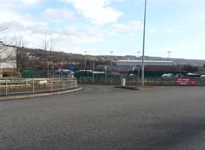
Look for this turn off the roundabout at the A650. For those who haven't been before, the Youtube video below will guide you round the playing fields. It was taken in January when we had just had all the rain. It's much drier than this in the summer!
Enter Marley Activity Centre through the gate then turn immediate
right and follow the unmade roadway round the lower playing field. Ignore any council signs about needing permission to drive past that point.
The club sails on Weecher reservoir situated on the Otley Road between East Morton and Menston, near High Eldwick, three and a half miles from Bingley centre. There are three reservoirs on this road. Weecher is the middle one. Please don’t be confused by the dinghy sailing club at Reva reservoir, the most eastery of the three.
Weecher Reservoir map reference is SE 136 422 and the coordinates for the car park are N53° 52.559′ W001° 47.672′.
Postcode BD16 3BE will get you very close to the reservoir.
Directions from South (M1). It will take you about 30 mins from the top of the motorway.
- As you approach Leeds on the M1 follow the signs for Leeds (Centre) M621 (do not keep following M1, this now veers off to join up with the A1).
- Follow Manchester M621 (M62) Right hand lane.
- You pass Leeds United football stadium on the left.
- Turn off at next junction (junction 1), turn right under motorway, signed Ring Road A6110.
- Keep following the Ring Road A6110.
- After 3 miles you join the dual carriageway Ring Road, the sign becomes Bradford A647.
- Keep on the ring road, straight across at the next two roundabouts.
- At third roundabout turn left off the Ring Road, signed Skipton A65 (please beware of speed cameras, they’re more common than trees just here!). Keep following Skipton A65.
- After 3 miles, pass Macdonalds on your left and at next big roundabout turn left to Shipley A6038.
- After 1 mile at give way junction, go straight over, signed Bradford Golf Club along Hawksworth Lane.
- Pass through Hawksworth village.
- Road becomes narrow and winding, after approx 1 mile you will come to a T junction, turn left, and after half a mile you will see the club on your left at a turn on the left with a 'Public Bridleway' sign. Turn left here and the gate for the KDMES car park will be found fifty yards on the right.
Local Directions from West - Find your way to Bingley (on the A650 between Shipley and Keighley)
- Locate traffic lights in the centre of Bingley
- Turn east into Park Road, which changes to Otley Road and leads to Eldwick Village. - Carry on through village and straight on up to the Fleece Inn (Dick Hudsons).
- Turn right at T junction towards Menston/Otley.
- You will see the club on your right after approx half a mile at a turn on the right with a 'Public Bridleway' sign. Turn right here and the gate for the KDMES car park will be found fifty yards on the right.
The lake is very high and exposed, so I would advise plenty of warm clothes and strong shoes. Launching is from a small jetty, or by wellies (recommended) anywhere along the bank. Should the sun make an appearance, you will be looking straight at it on part of the course, so sunglasses are useful. The clubhouse is a portakabin - rustic but function-able!
Printable instructions to Weecher Reservoir (30kB)
The boats sail at Redcar Tarn (also known as Keighley Tarn) above Keighley. Redcar Tarn is about a mile out of Keighley on Black Hill Lane. This is the road from Keighley to Whitley Head. Coordinates for the car park are N53° 52.570′ W001° 56.521′.